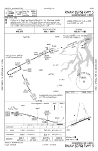
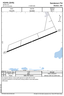


KSHN - Sanderson Fld
Located in Shelton, United States
ICAO - SHN, IATA -
Data provided by AirmateGeneral information
Coordinates: N47°14'1" W123°8'51"
Elevation is 272 feet MSL.
Magnetic variation is 15° East View others Airports in Washington
Operational data
Special qualification required
Current time UTC:
Current local time:
Weather
METAR: KSHN 041915Z AUTO 26005KT 6SM -RA BR BKN006 OVC055 11/10 A2951 RMK AO2 P0001 T01060100
Communications frequencies: [VIEW]
Runways:
| RWY identifier | QFU | Length (ft) | Width (ft) | Surface | LDA (ft) |
| 05 | 68° | 5005 | 100 | ASPH | |
| 23 | 248° | 5005 | 100 | ASPH |
Airport contact information
Address: Shelton United States
