


KSGR - Sugar Land Rgnl
Located in Houston, United States
ICAO - SGR, IATA -
Data provided by AirmateGeneral information
Coordinates: N29°37'20" W95°39'24"
Elevation is 81 feet MSL.
Magnetic variation is 05° East View others Airports in Texas
Operational data
Special qualification required
Current time UTC:
Current local time:
Weather
METAR: KSGR 012053Z 14010KT 10SM SCT024 BKN043 OVC055 28/23 A2981 RMK AO2 RAB11E48 SLP096 P0000 60000 T02830233 58017
TAF: KSGR 011726Z 0118/0218 13007KT P6SM SCT020 BKN050 FM012000 14012G20KT P6SM VCSH BKN030 FM020200 13010KT P6SM BKN015 FM021200 08011KT P6SM OVC007 FM021500 14014G21KT P6SM OVC015
Communications frequencies: [VIEW]
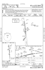
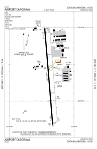
Runways:
| RWY identifier | QFU | Length (ft) | Width (ft) | Surface | LDA (ft) |
| 17 | 175° | 8000 | 100 | CONC | |
| 35 | 355° | 8000 | 100 | CONC |
Airport contact information
Address: Houston United States
