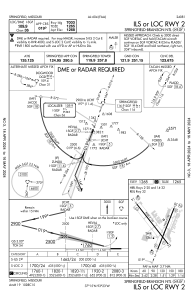
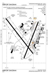


KSGF - Springfield-Branson Ntl
Located in Springfield, United States
ICAO - SGF, IATA - SGF
Data provided by AirmateGeneral information
Coordinates: N37°14'44" W93°23'19"
Elevation is 1268 feet MSL.
Magnetic variation is 03° East View others Airports in Missouri
Operational data
Special qualification required
Current time UTC:
Current local time:
Weather
METAR: KSGF 070715Z 13007KT 6SM TSRA BR SCT055 BKN075 OVC090 16/15 A2962 RMK AO2 LTG DSNT ALQDS TSB09 P0008 T01560150
TAF: KSGF 070539Z 0706/0806 16014G22KT P6SM SCT030 BKN050 OVC100 TEMPO 0706/0708 27030G45KT 2SM +TSRA BR BKN025 OVC050CB FM070800 20014G20KT P6SM SCT025 BKN050 OVC100 FM071400 23014G20KT P6SM FEW250
Communications frequencies: [VIEW]
Runways:
| RWY identifier | QFU | Length (ft) | Width (ft) | Surface | LDA (ft) |
| 02 | 22° | 7003 | 150 | CONC | 7003 |
| 20 | 202° | 7003 | 150 | CONC | 7003 |
| 14 | 142° | 8000 | 150 | CONC | 8000 |
| 32 | 322° | 8000 | 150 | CONC | 8000 |
Airport contact information
Address: Springfield United States

