


KSEP - Stephenville Clark Rgnl
Located in Stephenville, United States
ICAO - SEP, IATA -
Data provided by AirmateGeneral information
Coordinates: N32°12'55" W98°10'40"
Elevation is 1321 feet MSL.
Magnetic variation is 07° East View others Airports in Texas
Operational data
Special qualification required
Current time UTC:
Current local time:
Weather
METAR: KSEP 012255Z AUTO 12012KT 7SM SCT012 BKN022 OVC028 24/21 A2980 RMK AO2 T02430211
Communications frequencies: [VIEW]
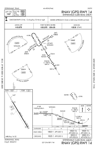
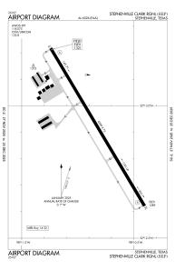
Runways:
| RWY identifier | QFU | Length (ft) | Width (ft) | Surface | LDA (ft) |
| 14 | 149° | 4209 | 75 | ASPH | |
| 32 | 329° | 4209 | 75 | ASPH |
Airport contact information
Address: Stephenville United States