


KSBM - Sheboygan County Meml
Located in Sheboygan, United States
ICAO - SBM, IATA - SBM
Data provided by AirmateGeneral information
Coordinates: N43°46'11" W87°51'6"
Elevation is 755 feet MSL.
Magnetic variation is -02° East View others Airports in Wisconsin
Operational data
Special qualification required
Current time UTC:
Current local time:
Weather
METAR: KSBM 282353Z AUTO 05011KT 7SM OVC002 07/07 A2987 RMK AO2 SLP117 60004 T00670067 10067 20050 58017 $
TAF: KSBM 282339Z 2900/2924 05013KT P6SM OVC004 FM290200 06005KT 1SM BR BKN002 WS020/19035KT FM290400 VRB04KT 1/4SM -SHRA FG BKN002 FM291300 18005KT 1SM BR BKN002 FM291500 21010KT P6SM BKN005 FM292300 24011G20KT P6SM FEW045
Communications frequencies: [VIEW]
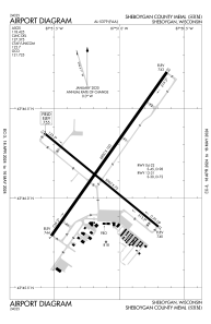
Runways:
| RWY identifier | QFU | Length (ft) | Width (ft) | Surface | LDA (ft) |
| 13 | 130° | 5002 | 75 | ASPH | |
| 31 | 310° | 5002 | 75 | ASPH | |
| 04 | 35° | 6800 | 100 | CONC | |
| 22 | 215° | 6800 | 100 | CONC |
Airport contact information
Address: Sheboygan United States
