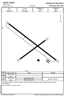


KRWF - Redwood Falls Muni
Located in Redwood Falls, United States
ICAO - RWF, IATA -
Data provided by AirmateGeneral information
Coordinates: N44°32'49" W95°4'55"
Elevation is 1023 feet MSL.
Magnetic variation is 04° East View others Airports in Minnesota
Operational data
Special qualification required
Current time UTC:
Current local time:
Weather
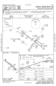
METAR: KRWF 070053Z AUTO 12020G32KT 10SM OVC055 22/10 A2954 RMK AO2 PK WND 11038/0027 SLP001 T02170100
TAF: KRWF 062331Z 0700/0724 13022G32KT P6SM BKN050 FM070300 14020G30KT 6SM -RA BR OVC035 TEMPO 0703/0707 2SM TSRA BR BKN025CB FM070700 14017G26KT 5SM -RA BR OVC040 FM071300 17012G19KT P6SM BKN050 FM072300 21014KT P6SM OVC100
Communications frequencies: [VIEW]
Runways:
| RWY identifier | QFU | Length (ft) | Width (ft) | Surface | LDA (ft) |
| 05 | 54° | 2081 | 200 | GRASS | |
| 23 | 234° | 2081 | 200 | GRASS | |
| 12 | 128° | 4001 | 100 | ASPH | |
| 30 | 308° | 4001 | 100 | ASPH |
Airport contact information
Address: Redwood Falls United States