


KRNT - Renton Muni
Located in Renton, United States
ICAO - RNT, IATA -
Data provided by AirmateGeneral information
Coordinates: N47°29'35" W122°12'57"
Elevation is 32 feet MSL.
Magnetic variation is 17° East View others Airports in Washington
Operational data
Special qualification required
Current time UTC:
Current local time:
Weather
METAR: KRNT 041153Z AUTO 00000KT 10SM FEW022 BKN029 OVC110 12/09 A2957 RMK AO2 SLP017 T01170094 10133 20117 56022
Communications frequencies: [VIEW]
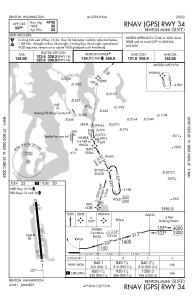
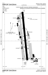
Runways:
| RWY identifier | QFU | Length (ft) | Width (ft) | Surface | LDA (ft) |
| 16 | 174° | 5382 | 200 | OTHER | 4742 |
| 34 | 354° | 5382 | 200 | OTHER | 4742 |
Airport contact information
Address: Renton United States
Other aviation service providers
Repair station

Flight schools

Boeing Employees Flying Association
Boeing Employees Flying Association
befa_office@mindspring.com+1(425)237-2332