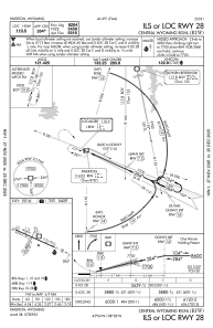
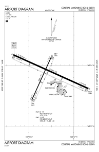


KRIW - Central Wyoming Rgnl
Located in Riverton, United States
ICAO - RIW, IATA - RIW
Data provided by AirmateGeneral information
Coordinates: N43°3'51" W108°27'35"
Elevation is 5515 feet MSL.
Magnetic variation is 10° East View others Airports in Wyoming
Operational data
Special qualification required
Current time UTC:
Current local time:
Weather
METAR: KRIW 030553Z AUTO 01008KT 10SM OVC080 05/M09 A2988 RMK AO2 SLP101 T00501089 10111 20028 58003
TAF: KRIW 030530Z 0306/0406 02014KT P6SM SCT050 OVC070 FM030930 03012KT 3SM -SN SCT008 OVC012 FM031700 02011KT 5SM -RA SCT008 OVC012 FM031900 03008KT P6SM BKN030 FM032100 VRB06KT P6SM SCT030
Communications frequencies: [VIEW]
Runways:
| RWY identifier | QFU | Length (ft) | Width (ft) | Surface | LDA (ft) |
| 01 | 24° | 4800 | 75 | ASPH | 4800 |
| 19 | 204° | 4800 | 75 | ASPH | 4800 |
| 10 | 114° | 8204 | 150 | ASPH | 8204 |
| 28 | 294° | 8204 | 150 | ASPH | 8204 |
Airport contact information
Address: Riverton United States