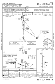
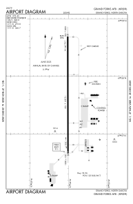


KRDR - Grand Forks Afb
Located in Grand Forks, United States
ICAO - RDR, IATA - RDR
Data provided by AirmateGeneral information
Coordinates: N47°57'41" W97°24'3"
Elevation is 911 feet MSL.
Magnetic variation is 03° East View others Airports in North Dakota
Operational data
Special qualification required
Current time UTC:
Current local time:
Weather
METAR: KRDR 010055Z 36005KT 6SM -RA BR FEW003 BKN025 OVC050 08/07 A2964 RMK AO2A TWR VIS 1 1/2 CIG 025V050 SLP049 P0013 T00840073 $
TAF: TAF AMD KRDR 302338Z 3023/0124 VRB06KT 4800 RA BR OVC002 650808 510063 QNH2964INS TEMPO 3023/0106 3200 +RA BR BECMG 0105/0106 27009KT 8000 BR OVC013 650804 621204 520052 510753 QNH2965INS BECMG 0108/0109 VRB06KT 2400 BR BKN006 650604 621003 QNH2976INS BECMG 0116/0117 VRB06KT 8000 BR BKN020 QNH2968INS TX14/0118Z TN02/0111Z
Communications frequencies: [VIEW]
Runways:
| RWY identifier | QFU | Length (ft) | Width (ft) | Surface | LDA (ft) |
| 18 | 180° | 12351 | 150 | ASPH | |
| 36 | 0° | 12351 | 150 | ASPH |
Airport contact information
Address: Grand Forks United States