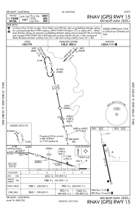
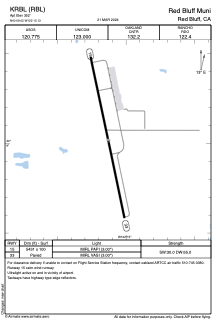


KRBL - Red Bluff Muni
Located in Red Bluff, United States
ICAO - RBL, IATA -
Data provided by AirmateGeneral information
Coordinates: N40°9'1" W122°15'8"
Elevation is 352 feet MSL.
Magnetic variation is 17° East View others Airports in California
Operational data
Special qualification required
Current time UTC:
Current local time:
Weather
METAR: KRBL 032154Z AUTO 11005KT 10SM CLR 28/M02 A2982 RMK AO2 SLP093 T02781022
TAF: KRBL 031721Z 0318/0418 35008KT P6SM SKC TEMPO 0318/0320 35011G16KT FM032200 16008KT P6SM SCT250 FM040700 15020G30KT P6SM VCSH OVC080 FM040900 18030G38KT P6SM -RA OVC050 FM041600 20011KT P6SM -RA OVC050
Communications frequencies: [VIEW]
Runways:
| RWY identifier | QFU | Length (ft) | Width (ft) | Surface | LDA (ft) |
| 15 | 168° | 5431 | 100 | ASPH | |
| 33 | 348° | 5431 | 100 | ASPH |
Airport contact information
Address: Red Bluff United States