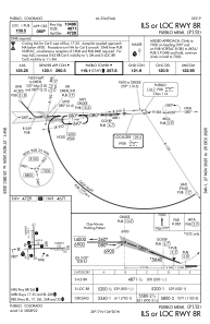
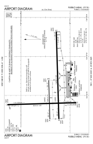


KPUB - Pueblo Meml
Located in Pueblo, United States
ICAO - PUB, IATA - PUB
Data provided by AirmateGeneral information
Coordinates: N38°17'24" W104°29'53"
Elevation is 4729 feet MSL.
Magnetic variation is 08° East View others Airports in Colorado
Operational data
Special qualification required
Current time UTC:
Current local time:
Weather
METAR: KPUB 030453Z AUTO 12019G28KT 10SM CLR 14/M01 A2991 RMK AO2 PK WND 11031/0439 SLP094 T01441011
Communications frequencies: [VIEW]
Runways:
| RWY identifier | QFU | Length (ft) | Width (ft) | Surface | LDA (ft) |
| 08L | 88° | 4690 | 75 | ASPH | 4690 |
| 26R | 268° | 4690 | 75 | ASPH | 4690 |
| 08R | 88° | 10498 | 150 | ASPH | 10496 |
| 26L | 268° | 10498 | 150 | ASPH | 10496 |
| 17 | 178° | 8310 | 150 | ASPH | 8308 |
| 35 | 358° | 8310 | 150 | ASPH | 8308 |
Airport contact information
Address: Pueblo United States
