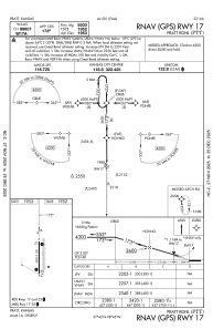
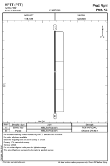


KPTT - Pratt Rgnl
Located in Pratt, United States
ICAO - PTT, IATA -
Data provided by AirmateGeneral information
Coordinates: N37°42'9" W98°44'49"
Elevation is 1952 feet MSL.
Magnetic variation is 07° East View others Airports in Kansas
Operational data
Special qualification required
Current time UTC:
Current local time:
Weather
METAR: KPTT 071110Z AUTO 28005KT 10SM CLR 07/02 A2962 RMK AO2 T00670022
Communications frequencies: [VIEW]
Runways:
| RWY identifier | QFU | Length (ft) | Width (ft) | Surface | LDA (ft) |
| 17 | 180° | 5500 | 100 | CONC | |
| 35 | 0° | 5500 | 100 | CONC |
Airport contact information
Address: Pratt United States