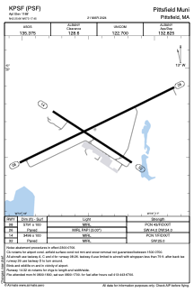


KPSF - Pittsfield Muni
Located in Pittsfield, United States
ICAO - PSF, IATA -
Data provided by AirmateGeneral information
Coordinates: N42°25'39" W73°17'27"
Elevation is 1188 feet MSL.
Magnetic variation is -15° East View others Airports in Massachusetts
Operational data
Special qualification required
Current time UTC:
Current local time:
Weather
METAR: KPSF 280354Z AUTO VRB03KT 10SM -RA OVC060 07/02 A3027 RMK AO2 SLP241 P0001 T00670022
TAF: KPSF 280340Z 2804/2824 17005G15KT P6SM -SHRA OVC090 TEMPO 2809/2813 -SHRA OVC015 FM281700 20006KT P6SM SCT020 BKN035 PROB30 2820/2824 5SM -SHRA BR OVC020
Communications frequencies: [VIEW]
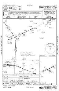
Runways:
| RWY identifier | QFU | Length (ft) | Width (ft) | Surface | LDA (ft) |
| 08 | 64° | 5791 | 100 | ASPH | |
| 26 | 244° | 5791 | 100 | ASPH | |
| 14 | 123° | 3496 | 100 | ASPH | |
| 32 | 303° | 3496 | 100 | ASPH |
Airport contact information
Address: Pittsfield United States
