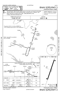
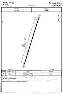


KPMZ - Plymouth Muni
Located in Plymouth, United States
ICAO - PMZ, IATA -
Data provided by AirmateGeneral information
Coordinates: N35°48'39" W76°45'30"
Elevation is 36 feet MSL.
Magnetic variation is -10° East View others Airports in North Carolina
Operational data
Special qualification required
Current time UTC:
Current local time:
Weather at : KEDE - Northeastern Rgnl ( 30 km )
METAR: KEDE 020545Z AUTO 00000KT 10SM CLR 20/20 A3001 RMK AO2 T01950195
Communications frequencies: [VIEW]
Runways:
| RWY identifier | QFU | Length (ft) | Width (ft) | Surface | LDA (ft) |
| 03 | 17° | 5500 | 75 | ASPH | |
| 21 | 197° | 5500 | 75 | ASPH |
Airport contact information
Address: Plymouth United States