


KPLN - Pellston Rgnl/Emmet County
Located in Pellston, United States
ICAO - PLN, IATA - PLN
Data provided by AirmateGeneral information
Coordinates: N45°34'15" W84°47'48"
Elevation is 720 feet MSL.
Magnetic variation is -06° East View others Airports in Michigan
Operational data
Special qualification required
Current time UTC:
Current local time:
Weather
METAR: KPLN 050154Z AUTO 00000KT 10SM CLR 14/10 A2982 RMK AO2 SLP097 T01440100
TAF: KPLN 042320Z 0500/0524 12010G16KT P6SM FEW045 FM050300 20006KT 6SM -SHRA BR OVC023 FM050900 31008G16KT P6SM BKN007 FM051200 31008G16KT P6SM SCT011 FM051700 31012G20KT P6SM FEW250
Communications frequencies: [VIEW]
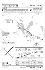
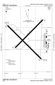
Runways:
| RWY identifier | QFU | Length (ft) | Width (ft) | Surface | LDA (ft) |
| 05 | 45° | 5401 | 150 | ASPH | 5395 |
| 23 | 225° | 5401 | 150 | ASPH | 5395 |
| 14 | 135° | 6513 | 150 | ASPH | 6512 |
| 32 | 315° | 6513 | 150 | ASPH | 6513 |
Airport contact information
Address: Pellston United States