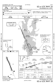
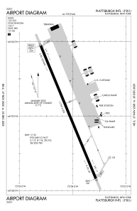


KPBG - Plattsburgh Intl
Located in Plattsburgh, United States
ICAO - PBG, IATA - PBG
Data provided by AirmateGeneral information
Coordinates: N44°39'3" W73°28'5"
Elevation is 234 feet MSL.
Magnetic variation is -15° East View others Airports in New York
Operational data
Special qualification required
Current time UTC:
Current local time:
Weather
METAR: KPBG 300353Z AUTO 28005KT 10SM FEW070 FEW110 09/04 A3006 RMK AO2 SLP180 T00890044
TAF: KPBG 292320Z 3000/3024 02005KT P6SM BKN100 FM301100 VRB04KT P6SM -SHRA OVC025 FM302100 03006KT 6SM -SHRA BR OVC018
Communications frequencies: [VIEW]
Runways:
| RWY identifier | QFU | Length (ft) | Width (ft) | Surface | LDA (ft) |
| 17 | 157° | 11759 | 200 | ASPH | 11759 |
| 35 | 337° | 11759 | 200 | ASPH | 11759 |
Airport contact information
Address: Plattsburgh United States