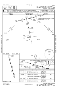
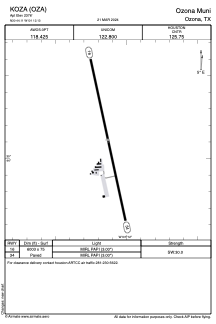


KOZA - Ozona Muni
Located in Ozona, United States
ICAO - OZA, IATA -
Data provided by AirmateGeneral information
Coordinates: N30°44'7" W101°12'8"
Elevation is 2376 feet MSL.
Magnetic variation is 08° East View others Airports in Texas
Operational data
Special qualification required
Current time UTC:
Current local time:
Weather
METAR: KOZA 011455Z AUTO 17015G19KT 7SM OVC010 22/19 A2987 RMK AO2
Communications frequencies: [VIEW]
Runways:
| RWY identifier | QFU | Length (ft) | Width (ft) | Surface | LDA (ft) |
| 16 | 168° | 6003 | 75 | ASPH | |
| 34 | 348° | 6003 | 75 | ASPH |
Airport contact information
Address: Ozona United States