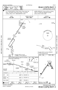


KOVE - Oroville Muni
Located in Oroville, United States
ICAO - OVE, IATA -
Data provided by AirmateGeneral information
Coordinates: N39°29'16" W121°37'19"
Elevation is 194 feet MSL.
Magnetic variation is 16° East View others Airports in California
Operational data
Special qualification required
Current time UTC:
Current local time:
Weather
METAR: KOVE 040253Z AUTO 14006KT 10SM CLR 24/06 A2975 RMK AO2 SLP076 T02390061 $
Communications frequencies: [VIEW]
Runways:
| RWY identifier | QFU | Length (ft) | Width (ft) | Surface | LDA (ft) |
| 02 | 33° | 6020 | 100 | ASPH | |
| 20 | 213° | 6020 | 100 | ASPH | |
| 13 | 144° | 3540 | 100 | ASPH | |
| 31 | 324° | 3540 | 100 | ASPH |
Airport contact information
Address: Oroville United States
