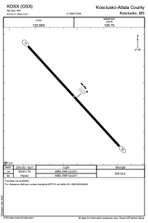


KOSX - Kosciusko-Attala County
Located in Kosciusko, United States
ICAO - OSX, IATA -
Data provided by AirmateGeneral information
Coordinates: N33°5'25" W89°32'31"
Elevation is 494 feet MSL.
Magnetic variation is -00° East View others Airports in Mississippi
Operational data
Special qualification required
Current time UTC:
Current local time:
Weather at : KGWO - Greenwood-Leflore ( 68 km )
METAR: KGWO 290853Z AUTO 19003KT 10SM OVC019 21/18 A2997 RMK AO2 SLP146 T02110183 56009
TAF: KGWO 290559Z 2906/3006 20008KT P6SM BKN080 OVC100 FM290700 16009KT P6SM BKN015 OVC030 FM291300 16013KT 4SM -SHRA VCTS BKN015CB OVC025 FM291800 21012KT 6SM BR VCSH OVC015
Communications frequencies: [VIEW]
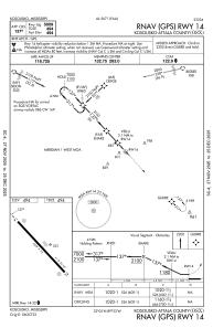
Runways:
| RWY identifier | QFU | Length (ft) | Width (ft) | Surface | LDA (ft) |
| 14 | 137° | 5009 | 75 | ASPH | |
| 32 | 317° | 5009 | 75 | ASPH |
Airport contact information
Address: Kosciusko United States