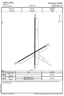


KOPL - St Landry Parish
Located in Opelousas, United States
ICAO - OPL, IATA -
Data provided by AirmateGeneral information
Coordinates: N30°33'30" W92°5'58"
Elevation is 74 feet MSL.
Magnetic variation is 01° East View others Airports in Louisiana
Operational data
Special qualification required
Current time UTC:
Current local time:
Weather
METAR: KOPL 031150Z AUTO 00000KT 7SM BKN008 BKN060 23/22 A2989 RMK AO2 LTG DSNT E THRU S 70048 T02250217 10228 20215
Communications frequencies: [VIEW]
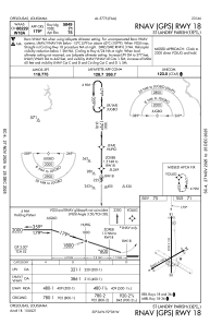
Runways:
| RWY identifier | QFU | Length (ft) | Width (ft) | Surface | LDA (ft) |
| 06 | 60° | 4051 | 100 | CONC | |
| 24 | 240° | 4051 | 100 | CONC | |
| 18 | 180° | 5999 | 100 | CONC | |
| 36 | 0° | 5999 | 100 | CONC |
Airport contact information
Address: Opelousas United States