


KOFK - Norfolk Rgnl/Karl Stefan Meml Fld
Located in Norfolk, United States
ICAO - OFK, IATA -
Data provided by AirmateGeneral information
Coordinates: N41°59'8" W97°26'6"
Elevation is 1572 feet MSL.
Magnetic variation is 05° East View others Airports in Nebraska
Operational data
Special qualification required
Current time UTC:
Current local time:
Weather
METAR: KOFK 292056Z AUTO 29013KT 10SM CLR 18/04 A2984 RMK AO2 SLP105 T01780039 56006
TAF: KOFK 291720Z 2918/3018 28013G19KT P6SM SCT030 FM300000 28009KT P6SM SKC FM300200 15003KT P6SM FEW200 FM301100 14008KT P6SM SCT200 WS020/21040KT FM301500 17014G23KT P6SM SCT200
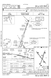
Communications frequencies: [VIEW]
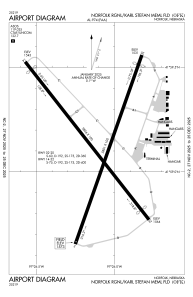
Runways:
| RWY identifier | QFU | Length (ft) | Width (ft) | Surface | LDA (ft) |
| 02 | 19° | 5801 | 100 | ASPH | |
| 20 | 199° | 5801 | 100 | ASPH | |
| 14 | 142° | 5806 | 100 | ASPH | 5160 |
| 32 | 322° | 5806 | 100 | ASPH | 5160 |
Airport contact information
Address: Norfolk United States