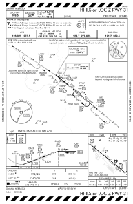
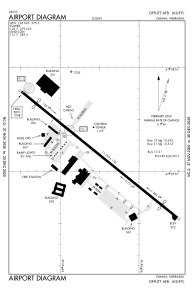


KOFF - Offutt Afb
Located in Omaha, United States
ICAO - OFF, IATA -
Data provided by AirmateGeneral information
Coordinates: N41°7'10" W95°54'31"
Elevation is 1048 feet MSL.
Magnetic variation is 02° East View others Airports in Nebraska
Operational data
Special qualification required
Current time UTC:
Current local time:
Weather
METAR: KOFF 292138Z AUTO 25012KT 10SM FEW055 21/08 A2983 RMK AO2 WSHFT 30 SLP104
Communications frequencies: [VIEW]
Runways:
| RWY identifier | QFU | Length (ft) | Width (ft) | Surface | LDA (ft) |
| 13 | 129° | 11703 | 150 | OTHER | 10695 |
| 31 | 309° | 11703 | 150 | OTHER | 10612 |
Airport contact information
Address: Omaha United States