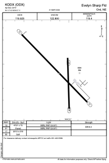


KODX - Evelyn Sharp Fld
Located in Ord, United States
ICAO - ODX, IATA -
Data provided by AirmateGeneral information
Coordinates: N41°37'25" W98°57'7"
Elevation is 2070 feet MSL.
Magnetic variation is 05° East View others Airports in Nebraska
Operational data
Special qualification required
Current time UTC:
Current local time:
Weather
METAR: KODX 291753Z AUTO 26009G15KT 220V280 10SM CLR 15/07 A2987 RMK AO2 SLP120 T01500072 10150 20022 58000
Communications frequencies: [VIEW]
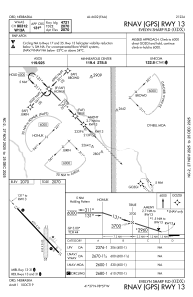
Runways:
| RWY identifier | QFU | Length (ft) | Width (ft) | Surface | LDA (ft) |
| 13 | 136° | 4721 | 75 | CONC | |
| 31 | 316° | 4721 | 75 | CONC | |
| 17 | 179° | 2012 | 218 | GRASS | |
| 35 | 359° | 2012 | 218 | GRASS |
Airport contact information
Address: Ord United States