


KNTU - Oceana Nas (Apollo Soucek Fld)
Located in Virginia Beach, United States
ICAO - NTU, IATA -
Data provided by AirmateGeneral information
Coordinates: N36°49'22" W76°1'55"
Elevation is 22 feet MSL.
Magnetic variation is -10° East View others Airports in Virginia
Operational data
Special qualification required
Current time UTC:
Current local time:
Weather
TAF: TAF KNTU 0323/0423 09015KT 9999 OVC005 QNH3005INS TEMPO 0323/0402 3200 BR OVC003 FM040400 09011KT 9000 BR OVC005 QNH3006INS TEMPO 0404/0410 1600 BR OVC003 FM041100 11012KT 9999 OVC006 QNH3007INS TX18/0420Z TN12/0404Z FN20107
Communications frequencies: [VIEW]
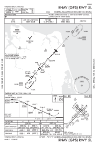
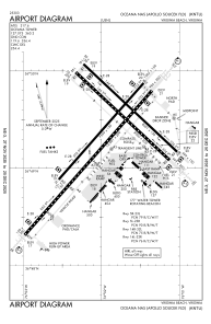
Runways:
| RWY identifier | QFU | Length (ft) | Width (ft) | Surface | LDA (ft) |
| 05L | 42° | 8000 | 150 | OTHER | |
| 23R | 222° | 8000 | 150 | OTHER | |
| 05R | 42° | 12001 | 200 | OTHER | |
| 23L | 222° | 12001 | 200 | OTHER | |
| 14L | 134° | 8001 | 150 | OTHER | |
| 32R | 314° | 8001 | 150 | OTHER | |
| 14R | 134° | 8000 | 200 | OTHER | |
| 32L | 314° | 8000 | 200 | OTHER |
Airport contact information
Address: Virginia Beach United States