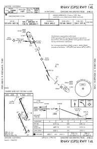
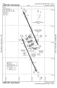


KNLC - Lemoore Nas (Reeves Fld)
Located in Lemoore, United States
ICAO - NLC, IATA -
Data provided by AirmateGeneral information
Coordinates: N36°19'59" W119°57'8"
Elevation is 228 feet MSL.
Magnetic variation is 14° East View others Airports in California
Operational data
Special qualification required
Current time UTC:
Current local time:
Weather
METAR: KNLC 031756Z 31009G17KT 10SM CLR 25/09 A2990 RMK AO2 SLP124 RH/36 T02500089 10250 20094 58001
TAF: TAF KNLC 0315/0415 34009KT 9999 SKC QNH2978INS FM032100 35010G15KT 9999 FEW048 QNH2975INS FM041100 VRB06KT 9999 FEW047 SCT160 BKN210 QNH2979INS TX29/0323Z TN11/0414Z FS30067
Communications frequencies: [VIEW]
Runways:
| RWY identifier | QFU | Length (ft) | Width (ft) | Surface | LDA (ft) |
| 14L | 156° | 13502 | 200 | CONC | |
| 32R | 336° | 13502 | 200 | CONC | |
| 14R | 156° | 13501 | 200 | CONC | |
| 32L | 336° | 13501 | 200 | CONC |
Airport contact information
Address: Lemoore United States