


KNGW - Cabaniss Fld Nolf
Located in Corpus Christi, United States
ICAO - NGW, IATA -
Data provided by AirmateGeneral information
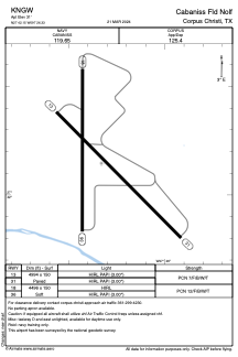
Coordinates: N27°42'9" W97°26'20"
Elevation is 31 feet MSL.
Magnetic variation is 05° East View others Airports in Texas
Operational data
Special qualification required
Current time UTC:
Current local time:
Weather at : KCRP - Corpus Christi Intl ( 10 km )
METAR: KCRP 011551Z 13013KT 9SM SCT012 BKN021 BKN033 OVC220 27/26 A2982 RMK AO2 SLP096 ACC SE T02670256
TAF: KCRP 011606Z 0116/0212 13014KT P6SM SCT012 BKN025 BKN200 FM011700 13018G25KT P6SM VCSH BKN025 FM020300 13014KT P6SM BKN015
Communications frequencies: [VIEW]
Runways:
| RWY identifier | QFU | Length (ft) | Width (ft) | Surface | LDA (ft) |
| 13 | 135° | 4994 | 150 | ASPH | |
| 31 | 315° | 4994 | 150 | ASPH | |
| 18 | 180° | 4496 | 150 | OTHER | |
| 36 | 0° | 4496 | 150 | OTHER |
Airport contact information
Address: Corpus Christi United States