


KNEL - Lakehurst Maxfield Fld
Located in Lakehurst, United States
ICAO - NEL, IATA - NEL
Data provided by AirmateGeneral information
Coordinates: N40°2'9" W74°21'5"
Elevation is 100 feet MSL.
Magnetic variation is -11° East View others Airports in New Jersey
Operational data
Special qualification required
Current time UTC:
Current local time:
Weather
METAR: KNEL 032300Z AUTO 11008KT 040V120 BKN016 11/07 A3019 RMK AO2 SLP223 T01110072 $
Communications frequencies: [VIEW]
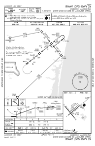
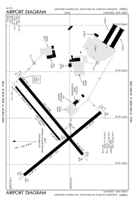
Runways:
| RWY identifier | QFU | Length (ft) | Width (ft) | Surface | LDA (ft) |
| 06 | 51° | 5002 | 150 | ASPH | |
| 24 | 231° | 5002 | 150 | ASPH | |
| 063 | 50° | 3500 | 90 | CONC | |
| 243 | 231° | 3500 | 90 | CONC | |
| 15 | 141° | 5001 | 150 | ASPH | |
| 33 | 321° | 5001 | 150 | ASPH |
Airport contact information
Address: Lakehurst United States