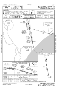
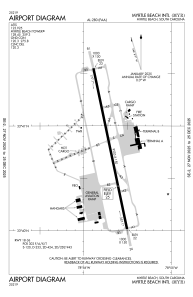


KMYR - Myrtle Beach Intl
Located in Myrtle Beach, United States
ICAO - MYR, IATA - MYR
Data provided by AirmateGeneral information
Coordinates: N33°40'47" W78°55'42"
Elevation is 25 feet MSL.
Magnetic variation is -09° East View others Airports in South Carolina
Operational data
Special qualification required
Current time UTC:
Current local time:
Weather
METAR: KMYR 280756Z 00000KT 10SM CLR 18/17 A3029 RMK AO2 SLP257 T01780172
TAF: KMYR 280520Z 2806/2906 13004KT P6SM BKN250 FM281400 14008KT P6SM SCT100 FM281700 16010KT P6SM SCT040
Communications frequencies: [VIEW]
Runways:
| RWY identifier | QFU | Length (ft) | Width (ft) | Surface | LDA (ft) |
| 18 | 168° | 9503 | 150 | ASPH | |
| 36 | 348° | 9503 | 150 | ASPH |
Airport contact information
Address: Myrtle Beach United States
