


KMRY - Monterey Rgnl
Located in Monterey, United States
ICAO - MRY, IATA - MRY
Data provided by AirmateGeneral information
Coordinates: N36°35'13" W121°50'34"
Elevation is 256 feet MSL.
Magnetic variation is 15° East View others Airports in California
Operational data
Special qualification required
Current time UTC:
Current local time:
Weather
TAF: KMRY 032320Z 0400/0424 29010G15KT P6SM FEW010 FM040200 27006KT P6SM OVC008 FM040600 26005KT P6SM OVC004 FM041700 21013G20KT 5SM -RA BR OVC009 FM042300 27014G22KT P6SM VCSH FEW020 SCT040
Communications frequencies: [VIEW]
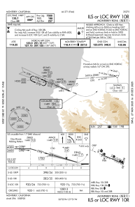
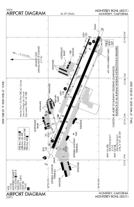
Runways:
| RWY identifier | QFU | Length (ft) | Width (ft) | Surface | LDA (ft) |
| 10L | 113° | 3503 | 60 | ASPH | |
| 28R | 293° | 3503 | 60 | ASPH | |
| 10R | 113° | 7175 | 150 | ASPH | 7000 |
| 28L | 293° | 7175 | 150 | ASPH | 7000 |
Airport contact information
Address: Monterey United States
Other aviation service providers
Flight schools

Aerodynamic Aviation - Monterey
Aerodynamic Aviation - Monterey
info@aerodynamicaviation.com+1(831)240-0800