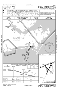
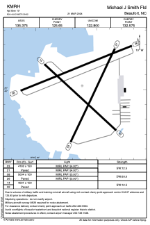


KMRH - Michael J Smith Fld
Located in Beaufort, United States
ICAO - MRH, IATA -
Data provided by AirmateGeneral information
Coordinates: N34°44'2" W76°39'37"
Elevation is 10 feet MSL.
Magnetic variation is -08° East View others Airports in North Carolina
Operational data
Special qualification required
Current time UTC:
Current local time:
Weather
METAR: KMRH 012358Z AUTO 20008KT 10SM CLR 22/19 A2997 RMK AO2 SLP149 T02220189 10256 20222 53005
Communications frequencies: [VIEW]
Runways:
| RWY identifier | QFU | Length (ft) | Width (ft) | Surface | LDA (ft) |
| 03 | 25° | 4192 | 150 | ASPH | |
| 21 | 205° | 4192 | 150 | ASPH | |
| 08 | 68° | 5004 | 100 | ASPH | |
| 26 | 248° | 5004 | 100 | ASPH | |
| 14 | 133° | 4001 | 100 | ASPH | |
| 32 | 313° | 4001 | 100 | ASPH |
Airport contact information
Address: Beaufort United States
