


KMQY - Smyrna
Located in Smyrna, United States
ICAO - MQY, IATA - MQY
Data provided by AirmateGeneral information
Coordinates: N36°0'32" W86°31'12"
Elevation is 543 feet MSL.
Magnetic variation is -02° East View others Airports in Tennessee
Operational data
Special qualification required
Current time UTC:
Current local time:
Weather
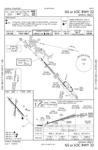
METAR: KMQY 301256Z 00000KT 10SM OVC080 17/17 A3002 RMK AO2 RAE1157 SLP169 T01720167
TAF: KMQY 301136Z 3012/0112 27005KT P6SM VCSH FEW035 OVC060 TEMPO 3012/3013 BKN005 BKN035 OVC060 FM301900 34005KT P6SM SCT045
Communications frequencies: [VIEW]
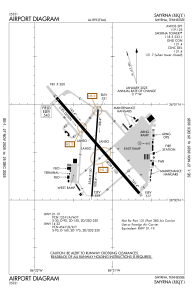
Runways:
| RWY identifier | QFU | Length (ft) | Width (ft) | Surface | LDA (ft) |
| 01 | 4° | 5546 | 100 | ASPH | |
| 19 | 184° | 5546 | 100 | ASPH | |
| 14 | 139° | 8038 | 150 | ASPH | |
| 32 | 319° | 8038 | 150 | ASPH |
Airport contact information
Address: Smyrna United States
