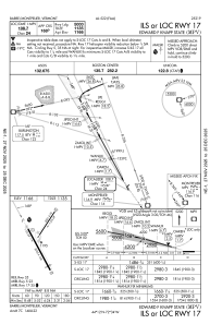
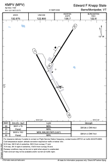


KMPV - Edward F Knapp State
Located in Barre/Montpelier, United States
ICAO - MPV, IATA - MPV
Data provided by AirmateGeneral information
Coordinates: N44°12'13" W72°33'44"
Elevation is 1165 feet MSL.
Magnetic variation is -16° East View others Airports in Vermont
Operational data
Special qualification required
Current time UTC:
Current local time:
Weather
METAR: KMPV 041951Z AUTO 18008KT 140V220 10SM SCT047 OVC100 19/07 A3029 RMK AO2 SLP260 T01890072
TAF: KMPV 041736Z 0418/0518 15008KT P6SM BKN070 FM050800 16008KT P6SM BKN029 FM051000 16009KT P6SM BKN019 FM051300 16011G17KT P6SM VCSH BKN023 FM051500 16012G18KT P6SM -SHRA OVC027 WS020/18040KT
Communications frequencies: [VIEW]
Runways:
| RWY identifier | QFU | Length (ft) | Width (ft) | Surface | LDA (ft) |
| 05 | 32° | 3001 | 75 | ASPH | |
| 23 | 212° | 3001 | 75 | ASPH | |
| 17 | 152° | 5000 | 100 | ASPH | |
| 35 | 332° | 5000 | 100 | ASPH |
Airport contact information
Address: Barre/Montpelier United States
