


KMLS - Frank Wiley Fld
Located in Miles City, United States
ICAO - MLS, IATA - MLS
Data provided by AirmateGeneral information
Coordinates: N46°25'37" W105°53'18"
Elevation is 2634 feet MSL.
Magnetic variation is 09° East View others Airports in Montana
Operational data
Special qualification required
Current time UTC:
Current local time:
Weather
METAR: KMLS 291153Z AUTO 00000KT 10SM BKN085 03/01 A2978 RMK AO2 SLP087 T00280011 10078 20028 56004
TAF: KMLS 291131Z 2912/3012 16007KT P6SM FEW090 SCT200 FM291500 32008KT P6SM BKN120 FM292100 VRB06KT P6SM FEW100 SCT200 FM300200 VRB06KT P6SM VCSH BKN080 FM300900 29015KT P6SM BKN045
Communications frequencies: [VIEW]
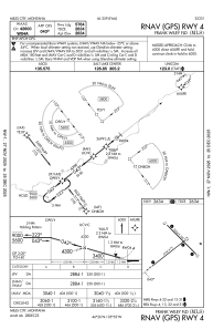
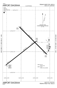
Runways:
| RWY identifier | QFU | Length (ft) | Width (ft) | Surface | LDA (ft) |
| 04 | 52° | 5764 | 75 | ASPH | 5764 |
| 22 | 232° | 5764 | 75 | ASPH | 5764 |
| 13 | 135° | 5624 | 100 | ASPH | 5624 |
| 31 | 315° | 5624 | 100 | ASPH | 5624 |
Airport contact information
Address: Miles City United States