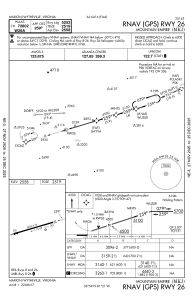
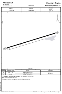


KMKJ - Mountain Empire
Located in Marion/Wytheville, United States
ICAO - MKJ, IATA -
Data provided by AirmateGeneral information
Coordinates: N36°53'41" W81°20'60"
Elevation is 2558 feet MSL.
Magnetic variation is -06° East View others Airports in Virginia
Operational data
Special qualification required
Current time UTC:
Current local time:
Weather
METAR: KMKJ 032135Z AUTO 27004KT 10SM -RA OVC070 18/15 A3012 RMK AO2 T01760153
Communications frequencies: [VIEW]
Runways:
| RWY identifier | QFU | Length (ft) | Width (ft) | Surface | LDA (ft) |
| 08 | 73° | 5252 | 75 | ASPH | |
| 26 | 253° | 5252 | 75 | ASPH |
Airport contact information
Address: Marion/Wytheville United States