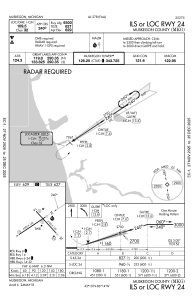
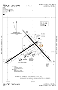


KMKG - Muskegon County
Located in Muskegon, United States
ICAO - MKG, IATA - MKG
Data provided by AirmateGeneral information
Coordinates: N43°10'4" W86°14'8"
Elevation is 628 feet MSL.
Magnetic variation is -04° East View others Airports in Michigan
Operational data
Special qualification required
Current time UTC:
Current local time:
Weather
METAR: KMKG 041955Z 23010KT 10SM SCT039 BKN250 26/13 A2992 RMK AO2 SLP130 T02560133 $
TAF: KMKG 041740Z 0418/0518 16012KT P6SM BKN250 FM050300 27005KT P6SM VCSH BKN035 OVC250 FM050600 29006KT P6SM VCSH OVC019 FM050800 33009G20KT 5SM BR VCSH OVC004 FM051200 34009KT 5SM BR OVC003 FM051500 34008KT P6SM BKN020
Communications frequencies: [VIEW]
Runways:
| RWY identifier | QFU | Length (ft) | Width (ft) | Surface | LDA (ft) |
| 06 | 56° | 6501 | 150 | ASPH | 6501 |
| 24 | 236° | 6501 | 150 | ASPH | 6501 |
| 14 | 137° | 6100 | 150 | ASPH | 6100 |
| 32 | 317° | 6100 | 150 | ASPH | 6100 |
Airport contact information
Address: Muskegon United States
