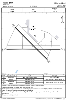


KMIV - Millville Muni
Located in Millville, United States
ICAO - MIV, IATA -
Data provided by AirmateGeneral information
Coordinates: N39°22'4" W75°4'20"
Elevation is 84 feet MSL.
Magnetic variation is -11° East View others Airports in New Jersey
Operational data
Special qualification required
Current time UTC:
Current local time:
Weather
METAR: KMIV 031854Z AUTO 09009G20KT 10SM OVC019 14/08 A3017 RMK AO2 SLP216 T01390083
TAF: KMIV 031739Z 0318/0418 08012G19KT P6SM SCT015 SCT250 TEMPO 0318/0322 BKN015 FM032200 09009KT P6SM BKN010 FM040400 09006KT P6SM BKN008 FM041500 09010KT P6SM VCSH BKN015
Communications frequencies: [VIEW]
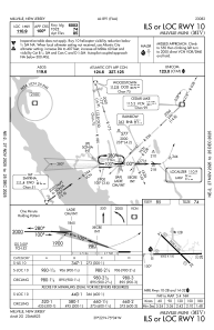
Runways:
| RWY identifier | QFU | Length (ft) | Width (ft) | Surface | LDA (ft) |
| 10 | 90° | 6003 | 150 | ASPH | |
| 28 | 270° | 6003 | 150 | ASPH | |
| 14 | 135° | 5058 | 150 | CONC | |
| 32 | 315° | 5058 | 150 | CONC |
Airport contact information
Address: Millville United States
