


KMGE - Dobbins Arb
Located in Marietta, United States
ICAO - MGE, IATA - MGE
Data provided by AirmateGeneral information
Coordinates: N33°54'52" W84°30'51"
Elevation is 1068 feet MSL.
Magnetic variation is -03° East View others Airports in Georgia
Operational data
Special qualification required
Current time UTC:
Current local time:
Weather
METAR: KMGE 022055Z VRB02KT 10SM FEW070 FEW150 SCT250 29/13 A2996 RMK AO2A SLP139 T02880126 58006
TAF: TAF KMGE 022100Z 0221/0403 VRB06KT 9999 FEW070 FEW150 SCT250 QNH2996INS BECMG 0311/0312 16009KT 9999 VCSH BKN040 OVC150 QNH3002INS BECMG 0314/0315 18010KT 9000 -SHRA BR VCTS OVC025CB QNH3005INS BECMG 0318/0319 22010G15KT 8000 -TSRA BR OVC018CB QNH3000INS BECMG 0321/0322 18005KT 9000 -SHRA BR VCTS OVC020CB QNH3001INS BECMG 0401/0402 VRB05KT 9000 -SHRA BR OVC025 QNH3003INS TX28/0320Z TN20/0312Z LAST NO AMDS AFT 0303 NEXT 0311
Communications frequencies: [VIEW]
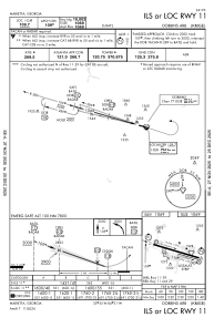
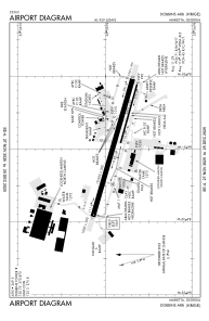
Runways:
| RWY identifier | QFU | Length (ft) | Width (ft) | Surface | LDA (ft) |
| 11 | 106° | 10002 | 300 | CONC | |
| 29 | 286° | 10002 | 300 | CONC | |
| 110 | 106° | 3495 | 60 | CONC | |
| 290 | 286° | 3495 | 60 | CONC |
Airport contact information
Address: Marietta United States