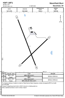


KMFI - Marshfield Muni
Located in Marshfield, United States
ICAO - MFI, IATA - MFI
Data provided by AirmateGeneral information
Coordinates: N44°38'13" W90°11'22"
Elevation is 1277 feet MSL.
Magnetic variation is 00° East View others Airports in Wisconsin
Operational data
Special qualification required
Current time UTC:
Current local time:
Weather
METAR: KMFI 282312Z AUTO 07011KT 2 1/2SM -RA BR FEW007 OVC015 06/05 A2989 RMK AO2 P0001 T00560050
Communications frequencies: [VIEW]
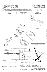
Runways:
| RWY identifier | QFU | Length (ft) | Width (ft) | Surface | LDA (ft) |
| 05 | 46° | 3597 | 100 | ASPH | |
| 23 | 227° | 3597 | 100 | ASPH | |
| 16 | 159° | 5002 | 100 | ASPH | |
| 34 | 339° | 5002 | 100 | ASPH |
Airport contact information
Address: Marshfield United States
Other aviation service providers
Flight schools

Duffys Aircraft Sales & Leasing, Inc.
Duffys Aircraft Sales & Leasing, Inc.
jeff@duffysaircraft.com7153872211