


KMEM - Memphis Intl
Located in Memphis, United States
ICAO - MEM, IATA - MEM
Data provided by AirmateGeneral information
Coordinates: N35°2'33" W89°58'36"
Elevation is 340 feet MSL.
Magnetic variation is -01° East View others Airports in Tennessee
Operational data
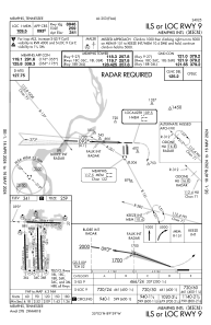
Special qualification required
Current time UTC:
Current local time:
Weather
METAR: KMEM 301654Z 19005KT 10SM SCT040 SCT200 24/16 A2999 RMK AO2 SLP151 T02440161
TAF: KMEM 301741Z 3018/0124 19005KT P6SM FEW040 FM010000 15003KT P6SM SKC FM011500 20006KT P6SM SKC
Communications frequencies: [VIEW]
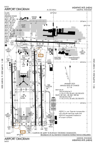
Runways:
| RWY identifier | QFU | Length (ft) | Width (ft) | Surface | LDA (ft) |
| 09 | 92° | 8946 | 150 | CONC | 8946 |
| 27 | 272° | 8946 | 150 | CONC | 8946 |
| 18C | 179° | 11120 | 150 | CONC | 11120 |
| 36C | 359° | 11120 | 150 | CONC | 10715 |
| 18L | 179° | 9000 | 150 | CONC | 9000 |
| 36R | 359° | 9000 | 150 | CONC | 9000 |
| 18R | 179° | 9320 | 150 | CONC | 9320 |
| 36L | 359° | 9320 | 150 | CONC | 9320 |
Airport contact information
Address: Memphis United States