


KMCI - Kansas City Intl
Located in Kansas City, United States
ICAO - MCI, IATA - MCI
Data provided by AirmateGeneral information
Coordinates: N39°17'51" W94°42'50"
Elevation is 1026 feet MSL.
Magnetic variation is 02° East View others Airports in Missouri
Operational data
Special qualification required
Current time UTC:
Current local time:
Weather
METAR: KMCI 071400Z 23009KT 10SM OVC005 17/16 A2954 RMK AO2 T01670156
TAF: KMCI 071359Z 0714/0812 22006KT P6SM BKN007 FM071500 22008KT P6SM FEW200 FM071800 23013G20KT P6SM SKC FM080000 21007KT P6SM FEW250
Communications frequencies: [VIEW]
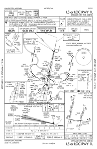
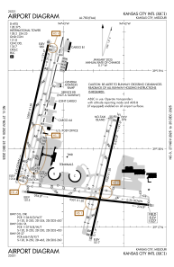
Runways:
| RWY identifier | QFU | Length (ft) | Width (ft) | Surface | LDA (ft) |
| 01L | 13° | 10801 | 150 | ASPH | 10801 |
| 19R | 193° | 10801 | 150 | ASPH | 10801 |
| 01R | 13° | 9500 | 150 | CONC | 9500 |
| 19L | 193° | 9500 | 150 | CONC | 9500 |
| 09 | 96° | 9501 | 150 | ASPH | 9501 |
| 27 | 276° | 9501 | 150 | ASPH | 9501 |
Airport contact information
Address: Kansas City United States
