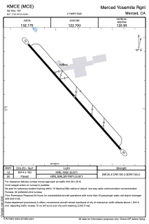


KMCE - Merced Yosemite Rgnl
Located in Merced, United States
ICAO - MCE, IATA - MCE
Data provided by AirmateGeneral information
Coordinates: N37°17'5" W120°30'50"
Elevation is 155 feet MSL.
Magnetic variation is 15° East View others Airports in California
Operational data
Special qualification required
Current time UTC:
Current local time:
Weather
METAR: KMCE 031953Z AUTO 32010KT 10SM CLR 26/07 A2987 RMK AO2 SLP115 T02610067
TAF: KMCE 031720Z 0318/0418 32009KT P6SM SKC FM041200 33006KT P6SM OVC250 FM041700 22010KT P6SM OVC050
Communications frequencies: [VIEW]
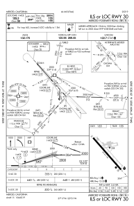
Runways:
| RWY identifier | QFU | Length (ft) | Width (ft) | Surface | LDA (ft) |
| 12 | 138° | 5914 | 150 | ASPH | |
| 30 | 318° | 5914 | 150 | ASPH |
Airport contact information
Address: Merced United States
