
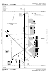


KMCC - Mc Clellan Airfield
Located in Sacramento, United States
ICAO - MCC, IATA - MCC
Data provided by AirmateGeneral information
Coordinates: N38°40'4" W121°24'2"
Elevation is 76 feet MSL.
Magnetic variation is 17° East View others Airports in California
Operational data
Special qualification required
Current time UTC:
Current local time:
Weather
METAR: KMCC 032115Z AUTO 00000G11KT 10SM CLR 26/02 A2985 RMK AO2
TAF: KMCC 031721Z 0318/0418 33007KT P6SM SKC FM040100 19009KT P6SM SCT250 FM040900 16014KT P6SM OVC120 FM041400 18020G26KT P6SM -RA OVC025
Communications frequencies: [VIEW]
Runways:
| RWY identifier | QFU | Length (ft) | Width (ft) | Surface | LDA (ft) |
| 16 | 180° | 10599 | 150 | CONC | |
| 34 | 0° | 10599 | 150 | CONC |
Airport contact information
Address: Sacramento United States
Other aviation service providers
Repair station

Flight schools

Flying Panthers Flight School, Inc
Flying Panthers Flight School, Inc
info@flyingpanthers.org+1(916)400-0330