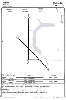


KMAW - Malden Rgnl
Located in Malden, United States
ICAO - MAW, IATA - MAW
Data provided by AirmateGeneral information
Coordinates: N36°35'54" W89°59'33"
Elevation is 295 feet MSL.
Magnetic variation is -01° East View others Airports in Missouri
Operational data
Special qualification required
Current time UTC:
Current local time:
Weather
METAR: KMAW 080315Z AUTO 18008KT 10SM CLR 25/22 A2967 RMK AO1
Communications frequencies: [VIEW]
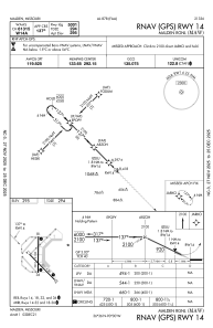
Runways:
| RWY identifier | QFU | Length (ft) | Width (ft) | Surface | LDA (ft) |
| 14 | 136° | 5001 | 80 | ASPH | |
| 32 | 316° | 5001 | 80 | ASPH | |
| 18 | 181° | 5010 | 100 | ASPH | |
| 36 | 1° | 5010 | 100 | ASPH |
Airport contact information
Address: Malden United States