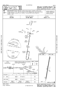


KLXY - Mexia-Limestone County
Located in Mexia, United States
ICAO - LXY, IATA -
Data provided by AirmateGeneral information
Coordinates: N31°38'28" W96°30'52"
Elevation is 544 feet MSL.
Magnetic variation is 04° East View others Airports in Texas
Operational data
Special qualification required
Current time UTC:
Current local time:
Weather
METAR: KLXY 011255Z AUTO 12003KT 7SM BKN009 OVC075 20/18 A2992 RMK AO2 T02000180
Communications frequencies: [VIEW]
Runways:
| RWY identifier | QFU | Length (ft) | Width (ft) | Surface | LDA (ft) |
| 18 | 189° | 5000 | 75 | ASPH | |
| 36 | 9° | 5000 | 75 | ASPH |
Airport contact information
Address: Mexia United States