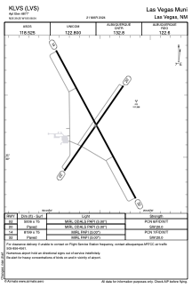


KLVS - Las Vegas Muni
Located in Las Vegas, United States
ICAO - LVS, IATA - LVS
Data provided by AirmateGeneral information
Coordinates: N35°39'15" W105°8'33"
Elevation is 6877 feet MSL.
Magnetic variation is 13° East View others Airports in New Mexico
Operational data
Special qualification required
Current time UTC:
Current local time:
Weather
METAR: KLVS 281853Z AUTO 05004KT 10SM BKN065 14/M02 A2994 RMK AO2 SLP082 T01441022
TAF: KLVS 281741Z 2818/2918 21008KT P6SM FEW070 FM282000 24012G22KT P6SM SCT090 FM290200 30012KT P6SM FEW100 SCT200 FM290600 34006KT P6SM SKC FM291600 24010KT P6SM SKC
Communications frequencies: [VIEW]
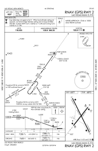
Runways:
| RWY identifier | QFU | Length (ft) | Width (ft) | Surface | LDA (ft) |
| 02 | 35° | 5006 | 75 | ASPH | |
| 20 | 215° | 5006 | 75 | ASPH | |
| 14 | 152° | 8199 | 75 | ASPH | |
| 32 | 332° | 8199 | 75 | ASPH |
Airport contact information
Address: Las Vegas United States