


KLGU - Logan-Cache
Located in Logan, United States
ICAO - LGU, IATA - LGU
Data provided by AirmateGeneral information
Coordinates: N41°47'30" W111°51'6"
Elevation is 4457 feet MSL.
Magnetic variation is 11° East View others Airports in Utah
Operational data
Special qualification required
Current time UTC:
Current local time:
Weather
METAR: KLGU 291851Z AUTO 21013G17KT 10SM FEW075 BKN110 17/02 A2987 RMK AO2 SLP087 T01670017
TAF: KLGU 291720Z 2918/3018 25009KT P6SM FEW070 BKN120 FM291900 25013G22KT P6SM VCSH BKN070 BKN120 FM300100 34015G25KT P6SM BKN120 FM300400 33008KT P6SM FEW120 FM300900 VRB04KT P6SM FEW200
Communications frequencies: [VIEW]
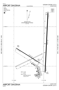
Runways:
| RWY identifier | QFU | Length (ft) | Width (ft) | Surface | LDA (ft) |
| 10 | 122° | 4075 | 60 | ASPH | |
| 28 | 302° | 4075 | 60 | ASPH | |
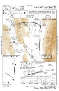
| 17 | 183° | 9020 | 100 | ASPH | 9020 |
| 35 | 3° | 9020 | 100 | ASPH | 9020 |
Airport contact information
Address: Logan United States
Other aviation service providers
Flight schools

Mountain Ridge Helicopters, Llc
Mountain Ridge Helicopters, Llc
info@mountainridgeheli.com+1(435)752-3828