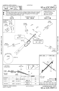


KLBT - Lumberton Rgnl
Located in Lumberton, United States
ICAO - LBT, IATA - LBT
Data provided by AirmateGeneral information
Coordinates: N34°36'35" W79°3'34"
Elevation is 124 feet MSL.
Magnetic variation is -08° East View others Airports in North Carolina
Operational data
Special qualification required
Current time UTC:
Current local time:
Weather
METAR: KLBT 020056Z AUTO 15006KT 10SM CLR 23/19 A2996 RMK AO2 SLP144 T02280189
TAF: KLBT 012341Z 0200/0224 00000KT P6SM SCT150 FM020500 00000KT 3SM BR SKC FM020800 00000KT 1SM BR SCT004 TEMPO 0208/0212 1/2SM FG VV004 FM021330 32003KT P6SM SCT030 FM021700 14004KT P6SM BKN045
Communications frequencies: [VIEW]
Runways:
| RWY identifier | QFU | Length (ft) | Width (ft) | Surface | LDA (ft) |
| 05 | 45° | 5502 | 150 | ASPH | |
| 23 | 225° | 5502 | 150 | ASPH | |
| 13 | 125° | 5003 | 75 | ASPH | |
| 31 | 305° | 5003 | 75 | ASPH |
Airport contact information
Address: Lumberton United States