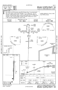
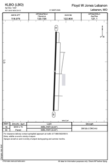


KLBO - Floyd W Jones Lebanon
Located in Lebanon, United States
ICAO - LBO, IATA -
Data provided by AirmateGeneral information
Coordinates: N37°38'54" W92°39'9"
Elevation is 1320 feet MSL.
Magnetic variation is 03° East View others Airports in Missouri
Operational data
Special qualification required
Current time UTC:
Current local time:
Weather
METAR: KLBO 070815Z AUTO 18008KT 7SM +TSRA SCT011 SCT060 OVC100 16/16 A2966 RMK AO2 P0009 LTG DSNT ALQS
Communications frequencies: [VIEW]
Runways:
| RWY identifier | QFU | Length (ft) | Width (ft) | Surface | LDA (ft) |
| 18 | 182° | 5000 | 75 | ASPH | |
| 36 | 2° | 5000 | 75 | ASPH |
Airport contact information
Address: Lebanon United States