
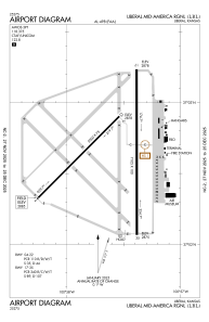


KLBL - Liberal Mid-America Rgnl
Located in Liberal, United States
ICAO - LBL, IATA - LBL
Data provided by AirmateGeneral information
Coordinates: N37°2'38" W100°57'36"
Elevation is 2885 feet MSL.
Magnetic variation is 06° East View others Airports in Kansas
Operational data
Special qualification required
Current time UTC:
Current local time:
Weather
METAR: KLBL 071256Z AUTO 25012KT 10SM CLR 12/M03 A2971 RMK AO2 SLP042 T01171028 PNO $
Communications frequencies: [VIEW]
Runways:
| RWY identifier | QFU | Length (ft) | Width (ft) | Surface | LDA (ft) |
| 04 | 45° | 5000 | 75 | CONC | 5000 |
| 22 | 225° | 5000 | 75 | CONC | 5000 |
| 17 | 180° | 7105 | 100 | CONC | 7105 |
| 35 | 360° | 7105 | 100 | CONC | 7105 |
Airport contact information
Address: Liberal United States
