


KLBB - Lubbock Preston Smith Intl
Located in Lubbock, United States
ICAO - LBB, IATA - LBB
Data provided by AirmateGeneral information
Coordinates: N33°39'49" W101°49'14"
Elevation is 3282 feet MSL.
Magnetic variation is 06° East View others Airports in Texas
Operational data
Special qualification required
Current time UTC:
Current local time:
Weather
METAR: KLBB 011853Z 19012KT 10SM FEW085 32/09 A2977 RMK TCU DSNT NE
TAF: KLBB 011720Z 0118/0218 20015G25KT P6SM SKC FM012100 17015G25KT P6SM SCT250 TEMPO 0123/0203 VRB50KT 2SM TSRA OVC030CB FM020300 14015KT P6SM OVC250 FM021600 32015KT P6SM SKC
Communications frequencies: [VIEW]
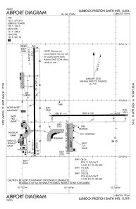
Runways:
| RWY identifier | QFU | Length (ft) | Width (ft) | Surface | LDA (ft) |
| 08 | 89° | 8003 | 150 | CONC | 8003 |
| 26 | 269° | 8003 | 150 | CONC | 8003 |
| 17L | 180° | 2891 | 74 | ASPH | 2891 |
| 35R | 360° | 2891 | 74 | ASPH | 2891 |
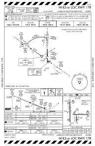
| 17R | 180° | 11500 | 150 | CONC | 11500 |
| 35L | 360° | 11500 | 150 | CONC | 11500 |
Airport contact information
Address: Lubbock United States
